
The floods that hit Bali in September 2025 were devastating. They took lives and left a trail of destruction in their wake. Then December brought rainfall among the worst on record, and more flooding with it. Some experts have estimated the 2025 rains at a one in 300 year event, others at up to one in 3,000.
But it’s worth looking into all the contributing factors besides the volume of rainfall. The severity of the floods also had to do with changes in land use over the past twenty years. Eco-Mantra’s co-founder and CEO, Maitri Fischer, having grown up in Bali since 1998, has seen these changes first hand. With a master’s in hydrology, he understands the important connection between Bali’s changing landscape to the floods and he was recently interviewed on the topic in the podcast For people. For Earth. For us. by Utama Spice. We’ve shared the interview below and the key insights in this article because they are relevant for anyone building or designing properties on the island.
Rain that has nowhere to go
In a typical year, about half of the rainfall that hits open land soaks into the soil, slowly making its way deeper, feeding the groundwater and arriving at waterways late, in small amounts. That type of slow absorption is the most effective form of flood protection that any area can have. But it relies entirely on the presence of bare soil, which allows the water to penetrate and soak in.
When you pave so much area like we’re paving in Bali, that rain doesn’t have anywhere to go but the ditch. It cannot percolate into the ground. So it goes into the ditches, the canals, the storm drains, and it finds its way into the rivers.
Maitri Fischer
Now, unable to percolate into the ground, an increased volume of water arrives at the river, and equally important, in a fraction of the time as water moves over pavement, roads and drains much faster than forests or landscapes covered in vegetation. Flood intensity depends on that timing as much as it depends on volume. So we now have a system that can store less water, meaning more rainwater volume is travelling above ground to waterways, and faster, as water flows quicker on paved surfaces than vegetated surfaces. This means we have larger flood water peaks, and the peak of floods are occurring much quicker. The drainage that is supposed to convey the shocking amount of water to larger rivers also has its own problems.
“Our roads are our storm drains, because the actual drainage on the side of the roads is silted up all the time. “Someone told me Bali is the only place where our bridges flood, and that’s because even the drains on the bridges clog up with trash, and therefore the bridges flood until the sidewalk level.”
Building where the water used to go
The other half of the problem is where the water collects. Every river has floodplains, these are low ground, within the river basin that naturally flood in heavy rain, and that ground is doing a job — it holds a large volume of water until the worst of the flood has passed. This is natural storage, natural flood buffers. It used to be wetlands, grasses and rice fields, and this land was cheap precisely because everybody knew it was prone to flooding.
“People are building kos-kosan (cheap rentals for domestic workers), perumahan (homes), villas, hotels in areas which are rawan banjir, are flood areas, because the price of primary land is so expensive, because there’s nowhere else to build,” Maitri says. “So this encroachment onto these really sensitive areas that typically already flood, they absorb a lot of that volume of flood water in heavy rains, and they’re being made smaller. People are building walls to define the size of the rivers so that they have more space for their villas.”
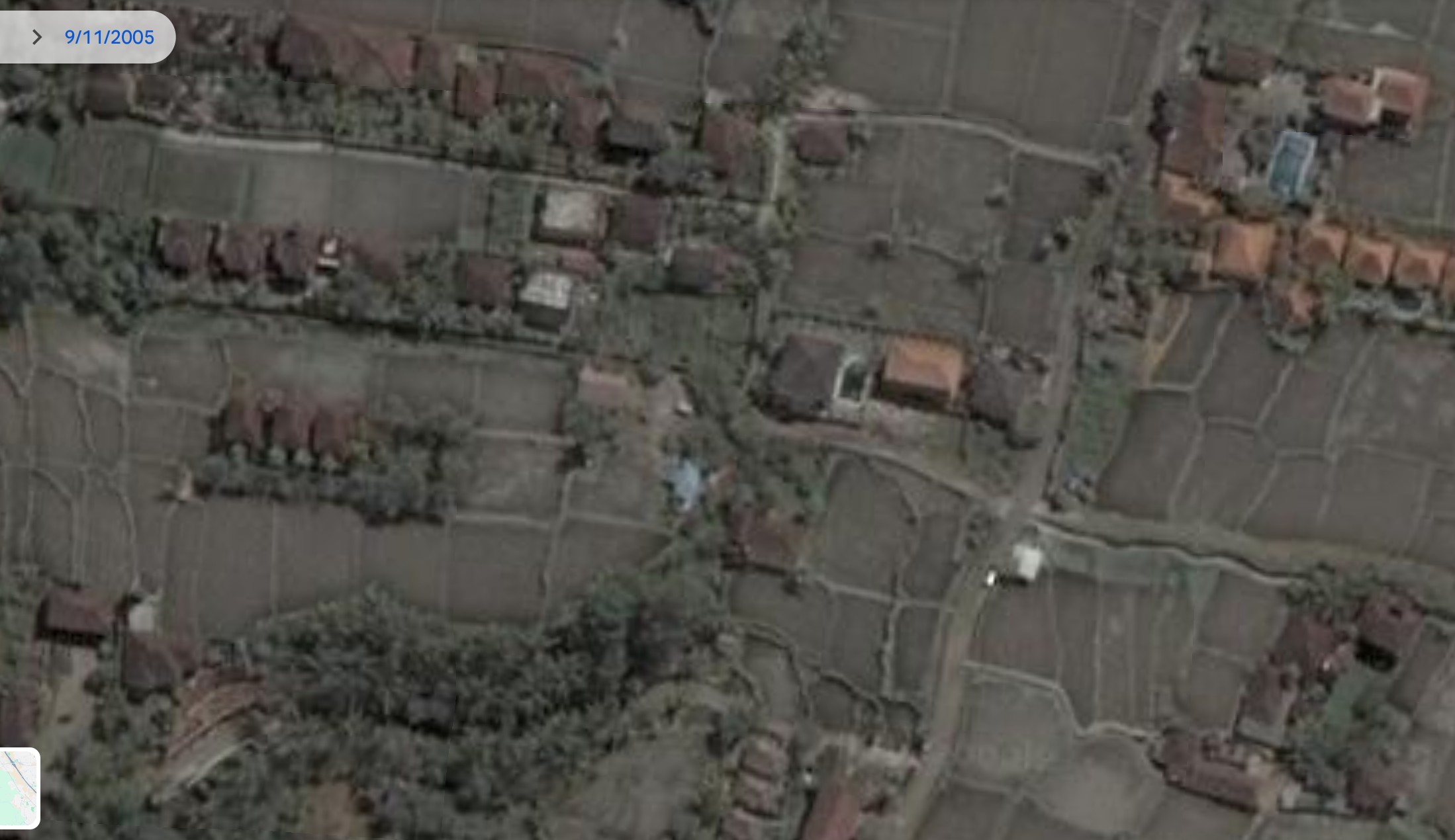
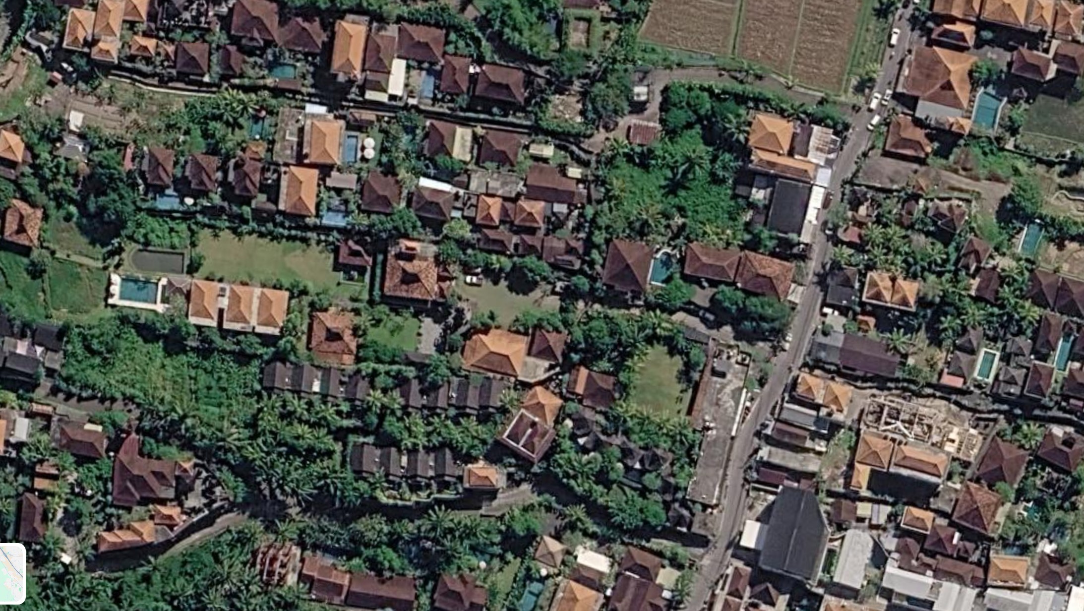
The same block near Ubud, twenty years apart. Rice terraces store and infiltrate rainwater; roofs, pools and paved terraces shed it. Imagery © Google Earth.
Alongside that, waterways are being straightened on the theory that a straight channel will help the water flow out faster. But it doesn’t really work that way.
“The science shows us that a meandering river stores a lot more water,” he says. “And the problem with the flood is storage.”
Put these two together and the math is not complicated. “When you encroach on flood plains, on flood zones, you make rivers smaller and you decrease how much water they can store in the natural system, you are only amplifying the water levels,” Maitri says. “And if there’s nowhere for them to be stored, they go up and over down the sides. That’s what happens. And it’s that simple.”
Fifty per cent on paper, ten per cent in the soil
One thing to think about when building in Bali is a zoning rule. In non-city areas, it states that you can only build on half of your land, and the other half needs to remain open green space. This rule is in place to protect the way water naturally soaks into the ground, and on paper compliance is widespread.
“A lot of this is interpreted to the benefit of the developer,” Maitri says. “It is unclear what 50% open green space means. It should mean soil and plants but the way that we’re interpreting it now is that it can include pools, it can include decks, it can include pathways. And none of those surfaces are permeable.”
How much of the developed plot of land is planted soil, open to the aquifers below, makes a difference.
“You have to have 50% green non-built-up area when you develop in this plot of land. But there’s really only 10% of soil, because everything else is hardscape — pools and decks and bales (gazebos),” he says. “We shouldn’t be counting that to green space.”
That’s how a building project can fulfil zoning obligations and still send a huge amount of rainwater, almost 90%, straight into the drainage system. If this happens with many properties in the same area, it can create flood conditions even before the rains start.
What can be done to reduce flood risk
It’s not possible to reverse the construction that’s already complete. So, what we are left with is a short list of measures that are within the control of whoever is designing an individual site.
The first is to interpret the zoning honestly, treating open green space as soil and plants and planning the hardscape around that figure rather than counting the pool and pool deck towards it.
The second is recharge wells. “Every development should have recharge wells. Every house should be adding them,” Maitri says. “It’s the same thing as a sumur resapan, as we say in bahasa — if you combine the resapan with an inlet of rainwater, you have some form of a recharge well. We need to be bringing water into the ground.” Not only will it recharge water into the ground, it also acts as temporary storage of rainwater, reducing flood water peaks in the rivers.
The third, where land is still available, is retention basins. “We need to store that flood water, because we’ve lost that storage in the natural environment,” he says. “So we need to build it artificially.”
None of this is technically difficult, and if planned in during the design stage of a project, costs a fraction of when it might be implemented later, retrofitted onto an existing property. We have written elsewhere about how detention, retention and infiltration work together across a resort site, and the same five functions apply on a single villa/home plot.